| Home |
|
|
|
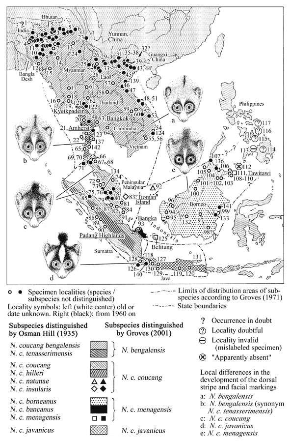
Distribution of slow loris forms
Nycticebus bengalensis
Intermediate bengalensis-coucang (synonym / subpopulation: N. c. tenasserimensis)
Nycticebus coucang coucang
Nycticebus coucang menagensis
Nycticebus coucang javanicus
All areas mentioned as
distribution
areas by at least one author were included. Based on data and
maps by:
Osman Hill 1953, Groves 1971, on the origin of museum
specimens
(Jenkins, 1987) and on specimen localities mentioned by other
authors (see
specimen list) The numbers
refer to
numbers of localities in the specimen lists. Names of type
localities (also
of some older subpopulations) are underlined.
Slow lorises: list of origin of described animals / specimens
General distribution: based on the distribution map in Osman Hill, 1953, and Groves, 1971, corrected with regard to specimen localities. In Vietnam widely distributed in forest areas, but common only in semi-evergreen and secondary forest, distribution from the north of Lang Son province, 210 30I N 1060 20I E, to the south of Tay Ninh province, 110 43I N 1080 48I E (Huynh 1998). In China in south and west Yunnan and Guangxi (Ji, Peng 1990)
N.
bengalensis (Lacépède, 1800), older synonym: N.
c.
bengalensis, including:
Subpopulation (synonym) N.
c.
bengalensis (Osman Hill 1953);
Subpopulation (synonym) N.
c.
tenasserimensis (Osman Hill 1953): here listed separately
because this
subpopulation seems to represent or include bengalensis-coucang
transition forms externally differing from typical bengalensis.
Distribution: Assam, Tippera,
Chittagong,
Burma, Siam, Laos and Annam (Osman Hill 1953). In China in south
and west
Yunnan and Guangxi (Ji, Peng 1990)
| No. | Origin | Altitude | Date | (Source) |
| Type locality: no type known, description based on "le paresseux pentadactyle du Bengale" (Vosmaer 1770) | ||||
| Bhutan / India: | ||||
| 1 | Distribution area on a map, no locality names given | Prior to 1998 | (Mani 1974) | |
| 2a | Manas
National Park,
Bhutan
(extends over the Indian Border into Bhutan) |
Prior to 1998 | (Gurung, Singh 1998) | |
| 2b | Manas National Park, India (see also above) | Prior to 1998 | (Gurung, Singh 1998) | |
| India: | ||||
| 3 | Goalpara | (Groves 1971) | ||
| 4 | Assam | (1992) | (Choudhury 1992) | |
| 5a | Arunachal Pradesh | (1992) | (Choudhury 1992) | |
| 5b | Pakhui sanctuary, Arunachal Pradesh (not found on maps) | Prior to 1996 | (Fitch-Snyder, pers. comm., quoting field guides) | |
| 6 | Namdapha National Park, Arunachal Pradesh | Prior to 1998 | (Gurung, Singh 1998) | |
| 7a | Nagaland | (1992) | (Choudhury 1992) | |
| 7b | (Kohima),
Naga Hills,
250 40I N, 940 07I E |
Prior to 1921 | (Groves 1971; Jenkins 1987) | |
| 7c | Naga Hills, 250 N 940 E | 1200 m | 1940 | (Groves 1971; Jenkins 1987) |
| 7d | Changpang,
Naga Hills,
250 N, 940 E 600 m |
1920 | (Groves 1971; Jenkins 1987) | |
| 8 | Manipur | (1992) | (Choudhury 1992) | |
| 9 | Mizoram | (1992) | (Choudhury 1992) | |
| 10a | Tripura | (1992) | (Choudhury 1992) | |
| 10b | Tripura state (north, south and west districts) (map with localities published) | 1976, 1978 | (Mukherjee 1982) | |
| 11a | Meghalaya | (1992) | (Choudhury 1992) | |
| 11b | Jaintia Hills, Megalaya | 1998 | (ASP bulletin, 22nd September 1998, quoted by Byrne 1997) | |
| Viable populations confined to Narpuh Reserved Forest and adjacent contiguous forests including Saipung Reserved Forest | ||||
| Bangla Desh | ||||
| 12a | Tipperah; Chittagong | (Groves 1971) | ||
| 12b | Chittigong
(Chittagong)
Hill Tract,
210 11I - 230 47I N, 910 41 - 920 42 I E |
Prior to 1929 | (Jenkins 1987) | |
| No. | Origin | Altitude | Date | (Source) |
| Myanmar (Burma): | ||||
| 13 | Bhamo;
Sumprabum,
260 33I N, 970 04I E |
Prior to 1950 | (Groves 1971; Jenkins 1987) | |
| 14 | Kindat,
20 miles west
W. bank of Chindwin River,
230 44I N, 940 26I E |
240 m | 1914 | (Groves 1971; Jenkins 1987) |
| 15 | Chin Hills | (Groves 1971) | ||
| 16 | Pathein
(Bassein),
160 30I N, 940 30I E |
1919 | (Groves 1971; Jenkins 1987) | |
| 17 | Toungoo Estate; Thaungdaung | 1350 m | 1929 | (Groves 1971, Jenkins 1987) |
| According to Jenkins (1987) synonym tenasserimensis | ||||
| 18 | 50 mi
north of Pegu,
170 20I N, 960 29I E |
60 m | 1916 | (Groves 1971; Jenkins 1987) |
| 19a | Taungyi;
Kyeikpadein;
(= Kyeikpadainggyi?), Lower Pegu,
170 14I N, 960 31I E |
1879 | (Groves 1971; Jenkins 1987) | |
| (Kyeikpadein: type locality of incanus Thomas) | ||||
| No. | Origin | Altitude | Date | (Source) |
| Yunnan, China: | ||||
| West and south Yunnan | (1995) | (Ji, Peng 1990, Huynh 1998) | ||
| 23 | Bijing-Fugong | (Prior to 1990) | (Ji, Peng 1990) | |
| 24 | Tongbiguan | (Prior to 1990) | (Ji, Peng 1990) | |
| 25 | A forest reserve near Jinghong County, Yunnan | (Prior to 1990) | (Ji, Peng 1990; Xu, Ren, Yuan 1981) | |
| (Jinghong = Yunjinghong = Yün-ching hung; town) | ||||
| 26 | Welyuanjiang | (Prior to 1990) | (Ji, Peng 1990) | |
| 27 | Hsi-Shuan-pan-na, China | (Groves 1971) | ||
| 28 | Mengyang; Menglun; Mengla; Shangyong | (Prior to 1990) | (Ji, Peng 1990) | |
| 29 | Huanglianshan | (Prior to 1990) | (Ji, Peng 1990) | |
| 30 | Jinping; Daweishan, Yunnan (map published) | (Prior to 1990) | (Ji, Peng 1990) | |
| 31 | Laojunshan, Yunnan (map published) | (Prior to 1990) | (Ji, Peng 1990) | |
| Guangxi, China: | ||||
| 32 | Southwest Guangxi (Guangsi); no locality mentioned | (Prior to 1990, prior to 1995) | (Ji, Peng 1990, Huynh 1998) | |
| No. | Origin | Altitude | Date | (Source) |
| Vietnam: | ||||
| Tonkin
region, North
Vietnam,
200 00I N - 230 30I N, 1020 00I E - 1080 00I E |
Prior to 1907; 1929 | (Fooden 1996) | ||
| 33 | Muong
Nhe Nature Reserve,
220 23I N, 1020 50I E: |
(1995) | (Huynh 1998) | |
| "one of the areas with highest density in Vietnam" | ||||
| 34 | Ta Lang,
Yen Bai,
ca. 210 45I N, 1040 30I E |
1963 | (Fooden 1996) | |
| 11c | Tat Ke
vic, 220
25I
N, 1050
25I
E
( = Kheo-Ting-Ta Ke area), Na Hang District, Tuyen Quang |
1992 | (Fooden 1996, quotingRatajsczcak. et al. 1992) | |
| 11d | Ban Bung vic., Na Hang District, Tuyen Quang, 220 20I N, 1050 20I E | 1992 | (Fooden 1996, quoting Ratajsczcak et al. 1992) | |
| 37 | Ban Be, 220 24I N 1050 38I E | (Fooden 1996) | ||
| 38a | Ba Be, Cho Ra District, Cao Bang Province, ca. 220 24I N, 1050 44I E | (Prior to 1995) | (Fooden 1996) | |
| 38b | Cho Ra.,
Cao Bang,
220 27I N, 1050 42I E |
(Prior to 1995) | (Fooden 1996) | |
| 39 | Na Hang
Nature Reserve,
Tuyen Quang (Ha Tuyen) Province,
220 14I N, 1050 30I E |
(1995) | (Huynh 1998) | |
| "one of the areas with highest density in Vietnam" | ||||
| 40a | Dai Sao; Cho Don District, Bac Thai, ca. 220 10I N, 1050 36I E | 1970 | (Fooden 1996) | |
| 40b | Ngoc Lac, Cho Don District, Bac Thai, 220 10I N, 1050 36I E | 1970 | (Fooden 1996) | |
| 41 | Ban Thi, Cho Don District, Bac Thai, 220 14I N, 1050 31I E | 1970 | (Fooden 1996) | |
| 42a | Thai
Nguyen (Bac Thai)
province, 210
10I
N - 220
23I
N,
1050 25I E - 1060 14I E |
? | (Fooden 1996) | |
| 42b | Dinh Ca, Thai Nguyen (Bac Thai) province, 210 44I N, 1050 57I E | 300 m | 1956;
(Prior to 1993) |
(Groves
1971; Fooden
1996;
Nisbett, Ciochon 1993) |
| 42c | Vicinity
of Dinh Ca,
210 45I N, 1060 03I E |
(Prior to 1993) | (Groves
1971;
Nisbett, Ciochon 1993) |
|
| 42d | Cho Don, Bac Can (Bac Thai) province, 220 09I N, 1050 35I E | (Prior to 1993) | (Nisbett, Ciochon 1993) | |
| 43a | Hoa Thong, Huu Lung District, Lang Son, ca. 210 30I N, 1060 20I E | 1964, 1965 | (Fooden 1996) | |
| 43b | Lang
Son, in the area
210 21I - 220 27I N, 1060 06I 1070 22I E |
1977 | (Fooden 1996) | |
| 44 | Thang Long, Song Don District, Ha Bac, ca. 210 19I N, 1060 52I E | 1968 | (Fooden 1996) | |
| 45a | Hoa Binh, Hoa Binh (Ha Son Binh) province, 200 49I N, 1050 21-22I E | 1943;
1990 (trade); prior to 1993) |
(Fooden
1996;
Nisbett, Ciochon 1993) |
|
| Thuong Tien; Hoa Binh (not located), 210 07I - 210 19I N, 1040 49I - 1050 52I E | (Prior to 1995) | (Fooden 1996) | ||
| 45b | Da Bac
Dist., Hoa Binh,
ca. 200 45I N, 1050 11I E |
(Prior to 1995) | (Fooden 1996) | |
| 139. | Ben En National Park | 2001 | Fitch-Snyder, Thanh 2002 | |
| In 1997 slow lorises were found in the park. In 2001, only one slow loris was found during a survey: caught in the park, confiscated from a local trader, probably because slow lorises can be sold to China for higher profit than the smaller pygmy lorises | ||||
| 46 | Pu Mat Nature Reserve | (1995) | (Huynh 1998) | |
| "one of the areas with highest density in Vietnam" | ||||
| 47 | Vu Quang
Nature Reserve,
160 26I N, 1050 33I E |
(1995) | (Huynh 1998) | |
| 48 | Kon Ha Nung on the Tay Nguyen Plateau, | (1995) | (Huynh 1998) | |
| "one of the areas with highest density in Vietnam" | ||||
| 49 | Hué | (Groves 1971) | ||
| 50 | Vicinity
of Hué,
Thua Tien-Hué,
160 28I N, 1070 36I E |
1929 | (Fooden 1996) | |
| 51 | Bach Ma Nat. Pk.; Thua-Tien-Hué, ca. 160 12I N, 1070 52I E | 1990-1995 | (Fooden 1996) | |
| 124 | Nui Chua Nature Reserve, Ninh Thuan province, central Vietnam, south of the Cam Ranh bay | 2001 | (Truong quang Tam, pers. comm.) | |
| Nature reserve with diverse vegetation ranging from evergreen low mountain vegetation to semid arid (low mountain) forest and , altitude of the highest peak in the area: 1040 m. Surveying of biological diversity started. | ||||
| 52 | Mom Ray Nature Reserve, Kon Tum, ca. 140 27I N, 1070 45I E | 1990-1995 | (Fooden 1996) | |
| 53 | Kong Cha
Rang-Kon Khi
Kinh.,
140 26I N, 1080 30I E, |
ca. 1990 - 1995 | (Fooden 1996) | |
| Kong Cha Rang-Nature Reserve area, 140 19I - 140 33I N 1080 24I- 1080 35I E | ||||
| 54 | Nhatrang | (Groves 1971) | ||
| 55 | Lao Bao,
Quang Tri,
160 37I N, 1060 36I E |
Prior to 1934 | (Groves 1971, Fooden 1996) | |
| No. | Origin | Altitude | Date | (Source) |
| Laos: | ||||
| 56 | Cat Tien
National Park,
110 27I N, 1070 19I E, |
(1995) | (Huynh 1998) | |
| "one of the areas with highest density in Vietnam" | ||||
| 57 | Xieng Khouang (Yiangkhoang) | 1994 | (Groves 1971, Duckworth, 1994) | |
| Phou Xang He protected area; south of Ban Khame, central Laos, 160 50I N, 1060 50I E | ||||
| 58 | Vientiane | (Groves 1971) | ||
| 59 | Pakse | (Groves 1971) | ||
| 60 | Thateng | (Groves 1971) | ||
| No. | Origin | Altitude | Date | (Source) |
| Thailand: | ||||
| 61 | Chiengmai | (Groves 1971) | ||
| 62 | 10 miles
S.W. of Raheng
(Tak),
160 52I N, 990 08I E |
120 m | 1913 | (Groves 1971; Jenkins 1987) |
| 63 | Bangkok,
130
44I
N, 1000
30I
E
Type locality of cinereus |
Prior to 1867 | (Groves 1971) | |
| 64 | Khao Soi Dow, Thailand | (Groves 1971) | ||
| 121 | Tak: Ban Mae Lamao (1 specimen of typical N. c. bengalensis collected) | (Fooden 1971) | ||
| 123 | Khao Sam Roi Yot Park | 2001 | (Frangipani.com website about national parks in Thailand, 2001) | |
| Slow lorises occurring. The encroachment of shrimp ponds into the park grounds has severely endangered the habitat of native and migratory wildlife. See also under N. c. tenasserimensis, 123 b | ||||
| 124 a | Erawan National Park in the Tenasserim Mountains | 2001 | (Frangipani.com website about national parks in Thailand, 2001) | |
| 550 km2 in size, slow lorises occurring. According to Osman Hill distribution area of the transition form tenasserimensis | ||||
| 124 b | Sri Nakarin reservoir park | 2001 | (Frangipani.com website about national parks in Thailand, 2001) | |
| Slow lorises occurring. Park badly degraded by cattle farmers and poachers. According to Osman Hill distribution area of the transition form tenasserimensis | ||||
Lorises listed as intermediate
N.
bengalensis -
N.
c. coucang (subpopulation / synonym N. c.
tenasserimensis
(Osman Hill 1953) and lorises from the tenasserimensis
distribution
area showing intermediate external features.
Distribution: Burma, Thailand:
wide area ranging from Chumphon north to Kampheng Phet (Osman
Hill 1953;
Lekagul, McNeely 1998).
| No. | Origin | Altitude | Date | (Source) |
| Myanmar (Burma) : | ||||
| 21a | Hinlaern; Amherst | (Groves 1971) | ||
| 21 b | Amherst: type locality of tenasserimensis (Pocock 1939) | |||
| 21b | Mergui
town, Tenasserim,
120 26I N, 980 36I E |
1914 | (Groves 1971; Jenkins 1987) | |
| 20 | Paungdaw
Power station,
forest of N.-W. of Tenasserim,
140 01I N, 980 33I E |
640 - 1000 m | 1961 | (Groves 1971; Jenkins 1987) |
| According to Jenkins (1987) synonym tenasserimensis | ||||
| Thailand: | ||||
| 21 c | Amherst, N. Tenasserim: type locality of tenasserimensis | (Pocock 1939) | ||
| 122 | Kamphaeng Phet: Ban Mae Na Ree (3 specimens of N. c. tenasserimensis collected) | . | (Fooden 1971) | |
| Northern limit of the zone where intermediate bengalensis/coucang forms are found (Lekagul, McNeely 1998). Facial markings: indistinct stripes to ears and eyes in the tree specimens collected (Fooden 1971). | ||||
| 142 | Chumphon | . | (Lekagul, McNeely 1998) | |
| According to Lekagul and McNeely (1998) Chhumphon marks the southern limit of the zone where intermediate bengalensis/coucang forms are found. According to Osman Hill (1953) and Groves (1971) such forms occur even further south, approximately up to Surat Thani. | ||||
| 123 b. | Kaen Kra Chan, Thailand (near Petchaburi, about 150 km southwest of Bangkok, close to the border to Burma. | 2003 | Streicher, Ulrike, pers. comm., animal brought to the WFFT wildlife rescue center in Petchaburi. | |
| ? According to Osman Hill distribution area of southern N. bengalensis / synonym N. c. tenasserimensis, but more similarity with N. c. coucang in colour and facial markings, only with rather lightcoloured neck. | ||||
| 137 | Koh Lok, 110 50IN, 990 50I E, island off the coast of Prachuap Province | 1916, 1917 | Groves, Colin, pers. comm., museum specimen data; Lekagul, McNeely 1998 quoting Moss 1916, 1917 | |
| Two lorises collected: one with a dorsal stripe ending at the occiput as in bengalensis, the other having the dorsal stripe bifurcating at the crown and continuing to the eyes as in tenasserimensis (Lekagul, McNeely 1998). | ||||
| 138 | Kanchanaburi | 2001 | Lekagul, McNeely 1998 | |
| 2 specimens in the Thai National Reference Collection: one has faint lines connecting the dorsal stripe with the eyes and ears, the other has a dorsal stripe continuing to the occiput, no facial forkmarks. | ||||
N.
c.
coucang Boddaert, 1784, including:
subpopulation (synonym) N.
c.
coucang (Osman Hill 1953)
subpopulation (synonym) N.
c.
hilleri (Osman Hill 1953)
subpopulation (synonym) N.
c.
natunae (Osman Hill 1953)
subpopulation (synonym) N.
c.
insularis (Osman Hill 1953)
Distribution: Malaysian peninsula from the Isthmus of Kra
(southern
Thailand) southward, Singapore. Islands: Ko Phuket (= Jung Ceylon
Island);
Penang (Pinang) island; Tioman Island (form of Tioman maybe
distinct?).
Mergui archipelago (Burma). Indonesia: Sumatra; islands: Pulau
Tebingtinggi,
the Riau (Rhio) archipelago islands Batam and Galang and the North
Natuna
island Bunguran.
| No. | Origin | Altitude | Date | (Source) |
| Type locality: unknown | ||||
| Myanmar (Burma) : | ||||
| 22. | King´s
Island
(Kadan Kyun), Mergui Archipelago,
120 30I N, 980 22I E |
1921 | (Groves 1971; Jenkins 1987) | |
| ? Listed as N. c. coucang, but the adjacent mainland according to Osman Hill is distribution area of southern N. bengalensis / synonym N. c. tenasserimensis. Description of a male from King´s Island, according to Pocock 1939: dorsally and ventrally rich rusty-ochreous, nape buffy-grey laterally, limbs distally paler, but not white. Chest greyer than belly. Dorsal stripe deep brown, on nape paler and redder, facial stripes defined by ashy-grey on forehead and cheeks. Centre of crown ochraceous (less reddish than in a comparable specimen from Malaysia). | ||||
| Thailand: | ||||
| 65 | Salanga
(Salang), on
Junk Ceylon Island (= Ko Phuket),
080 00I N, 980 20I E |
1901 | (Jenkins 1987) | |
| 66 | Khaw Song Mt., Trang | (Groves 1971) | ||
| 67 | (Kampong)
Biserat;
(R.Pattani); Jalor (= Yala?),
060 32I N, 1010 14I E |
1901 | (Jenkins 1987) | |
| Peninsular Malaysia, Malaya: | ||||
| 68 | Jambu;
Jhering (= Yarang),
060 45I N, 1010 15I E |
1901 | (Jenkins 1987) | |
| 69 | Ban Tap Plik, Changwat (= Province) Krabi | 1973 | (Fooden 1976) | |
| 70a | Ban Krung Khayan, Changwat (= Province) Nakhon Si Thammaret | 1973 | (Fooden 1976) | |
| 70b | Ban Thap Plik (1 km N.E.) | (Fooden 1976) | ||
| 70c | Ban Krung Khayan (0.5 km W.) | (Fooden 1976) | ||
| 71 | Langkawi Island, Malaya | 2000 | (J. Zimmerer, pers. comm.) | |
| Photo of an animal held as a pet or charm, by J. Zimmerer, showing an animal looking like N. c. coucang | ||||
| 72a | Penang | (Groves 1971) | ||
| 72b | Telok
Bahang, Penang
(Pinang) Island, Malaya,
050 28I N, 1000 13I E |
1911 | (Jenkins 1987) | |
| 72c | Pinang;
Pinang Island;
Province Wellesley (Pinang), Malaya,
050 25I N, 1000 20I E |
Prior to 1888, 1896 | (Jenkins 1987) | |
| 73a | Bukit Gantong (Gantang), Perak, Malaya, 040 47I N, 1000 46I E | 1911 | (Jenkins 1987) | |
| 73b | Rumpin river; Batu Gantong; Malaya | (Groves 1971) | ||
| 73c | Pulo
(Pulao) Pangkor;
Dindings, Perak, Malaya,
040 13I N, 1000 34I E |
1909 | (Jenkins 1987) | |
| 73d? | Tremangan,
Ligeh, Patani,
Malaya,
ca. 05 N, 1000 E (?) Not found on maps |
1899 | (Jenkins 1987) | |
| 74 | Trengganu, Malaya | (Groves 1971) | ||
| 75a | Lima Belas Estate | Prior to 1981 | (Barrett 1981) | |
| No. | Origin | Altitude | Date | (Source) |
| 75b | Changkat
Mentri (Sungai
Changkat Menteri), Perak, Malaya,
030 43I N, 1010 15I E |
Prior to 1955 | (Jenkins 1987) | |
| 76a | Ulu
Gombak; Ulu Gombok;
Selangor, near Kuala Lumpur,
030 18I N, 1010 47I E |
488 m | 1909 | (Groves 1971, Jenkins 1987) |
| 76b | Bukit Lagong Forest Reserve, | 1949 | (Jenkins 1987) | |
| Kepong, Selangor, Malaya, 030 15I N, 1010 37I E. In a later survey no lorises found (Barrett 1981) | ||||
| 76c | Bukit Lanjan, Sungai Buloh Forest Reserve, near Kuala Lumpur | Prior to 1970; 1994 | (Whittow et al. 1977; Wiens 1995) | |
| 14 slow lorises caught in traps (whittow et al. 1977); 1 animal examined in a field study (Wiens 1995) | ||||
| 76d | Sg. Buloh (4 animals examined in a field study) | 1994 | (Wiens, 1995) | |
| 76e | Bkt. Mandol (1 animals examined in a field study) | 1994 | (Wiens, 1995) | |
| 77 | Sungai Tekam Forestry Concession | Prior to 1981 | (Barrett 1981) | |
| 78 | Gunong
Benom Base Camp,
Malaya,
030 50I N, 1020 06I E |
244 m | 1967 | (Jenkins 1987) |
| 79a | Kepong,
Selangor, Malaya,
030 14I N, 1010 38I E |
1994-2000 | (Wiens,
1995;
Wiens, Zitzmann, pers. comm.) |
|
| 79b | Ayer Hitam Forest Reserve, Selangor | Prior to 1981 | (Barrett 1981) | |
| 134 | Manjung district, Perak: Segari Melintang, Tanjung Hantu and Batu Undan forest reserves, area around the village Labuan Bilek; 04018I N, 100034I E | . | 1995, 1999 | (Wiens, 2002) |
| .. | Unlogged and logged-over lowland dipterocarp forest and freshwater alluvial swamp forest, secondary Padang savannawith some crop trees (coconut, cashew, kapok trees) | |||
| 80 | Pasoh Forestry Research Centre | Prior to 1981 | (Barrett 1981) | |
| 81 | Johore Lamu; Jambu; Biserat, Malaya | . | (Groves 1971) | |
| 82 | Malacca
(Melaka), Malaya,
020 15I N, 1020 15I E |
1877 | (Jenkins 1987) | |
| 83a | Pulao
Tioman, Malaya
Type locality of insularis Robinson |
(Groves 1971) | ||
| 83b | Juara
Bay (Telok Juara),
020 48I N, 1040 13I E, or |
1911 | (Jenkins 1987) | |
| 83 c | Sungei Nipa (Sungai Nipah), 020 44I N, 1040 13I E, Pulau Tioman, E. Central Pahang, Malaya | |||
| Bukit Blinja, Malaya (not located) | 1899, 1915 | (Jenkins 1987) | ||
| Komlom, opposite Singora, Malaya (not located) | 1899 | (Jenkins 1987) | ||
| Singapore: | ||||
| 84 | 010 17I N, 1030 51I E | 1895 | (Jenkins 1987) | |
| Indonesia: | ||||
| 85 | Padang Bahrang, Delhi, Tandjong Morawa; Siantar, Sumatra | 1879-1982 | (Groves 1971; Jenkins 1987) | |
| 86 | Tapanuli Bay, Sumatra | (Groves 1971) | ||
| 87 | Pulao
Tebingtinggi,
Sumatra
Type locality of brachycephala Sody |
(Groves 1971) | ||
| 88 | Fort de
Kock (= Bukittinggi),
west coast of Sumatra,
000 19I N, 1000 22I E |
920 m | 1926 | (Groves 1971; Jenkins 1987) |
| 89 | Batu Sangkar, Tarussan Bay, Sumatra | (Groves 1971) | ||
| 90 | Padang
Highlands, Sumatra
Type locality of hilleri Stone and Rehn |
(Groves 1971) | ||
| 91 | Riau (Rhio) Archipelago: Batam | (Groves 1971) | ||
| 92 | Natuna Islands, Bunguran Besar = Natuna Besar (Natuna main island) | Prior to 2001 | Indrawan, Rangkuti 2001 | |
| Practically all lowland forests meanwhile cut down. Primary forest only left on the slopes of Mount Ranai. Sympatric diurnal primates (Macaca fascicularis pumila, Presbytis femoralis natunae) were discovered relatively frequently during surveying, but occurrence of slow lorises usually only indirectly discovered, based on personal communication (Indrawan, Rangkuti 2001 | ||||
| 92 b | North Natuna Island: Sibintang (Pulau Natuna Besar, Kepulauan Natuna Besar), 040 00I N, 1080 15I E | 1939 | (Groves 1971; Jenkins 1987) | |
| 92 c | North Natuna: Bunguran Island (= Pulau Natuna Besar, Kepulauan Natuna Besar), 040 00I N, 1080 15I E | 1871 | (Groves 1971; Jenkins 1987) | |
| Type locality of natunae Stone and Rehn | ||||
N.
c.
menagensis Trouessart, 1898:
subpopulation (synonym) N.
c.
menagensis (Osman Hill 1953):
subpopulation (synonym) N.
c.
bancanus (Osman Hill 1953):
subpopulation (synonym) N.
c.
borneanus (Osman Hill 1953):
Distribution: Borneo: Kalimantan, Sarawak, Sabah, Brunei. Belitung
Island, Bangka Island. Philippines: some islands of the Tawi Tawi
Archipelago.
Occurrence on Mindanao in question (possibly introduced)
| No. | Origin | Altitude | Date | (Source) |
| Type locality: unknown | ||||
| Bangka: | ||||
| 93 | Bangka,
Klabat Bay
Type locality of bancanus Lyon |
(Groves 1971) | ||
| Belitung: | ||||
| 125 | Museum specimens from Belitung Island | ? | Groves 2003, pers. comm | |
| Borneo: | ||||
| 94 | Sungei Landak | (Groves 1971) | ||
| 95 | Sungei Kapuas; S. Sakaiam, Sanggau district | (Groves 1971) | ||
| Probable type locality of brachycephala Sody | ||||
| 96a | Kuching,
Sarawak,
010 33I N, 1100 20I E |
Prior to 1923 | (Jenkins 1987) | |
| 96b | Matang
Range, Sarawak,
010 36I N, 1100 11I E |
c. 900 m | 1937 | (Jenkins 1987) |
| 97 | Puruk
Tjahu (Poeroeck
Tjahoe), Barito River, South Central Borneo
000 35I S 1140 35I E |
35 m | 1909 | (Groves 1971; Jenkins 1987) |
| 98 | Tameang Lajang (Tamianglajang), | Prior to 1888 | (Jenkins 1987) | |
| Sihong District, Tatai (Kalimantan), 020 07I S 1150 10I E (locality name not found on maps) | ||||
| 99 a | Samarinda | (Groves 1971) | ||
| 99 b | Samarinda, E. Borneo
0° 30I 0 S, 117° 9I 0 E |
1932 | Data courtesy of the MZB
Location, coordinates: Global Gazetteer website |
|
| 133 | Kalimantan,
116º 54' E and 1º 16' S |
2003 | Streicher, Ulrike , pers. comm. | |
| 141 | Kutai National Park, Kalimantan | Prior
to?
2003 |
Firama PhotoGraphic website: Taman Nasional Indonesia, seen in 2003 | |
| 100 | Mt.
Dulit (Baranjan
Dulit), Baram District, Sarawak,
030 15I N, 1140 15I E |
300 m | 1897 | (Groves 1971; Jenkins 1987) |
| 101a | Mainland opposite Labuan Island (Sabah), 050 19I N, 1150 20I E | 1871 | (Groves 1971; Jenkins 1987) | |
| 102 | Tawau, forest roadside near experimental station, (Sabah), Sarawak | Prior to 1879 | (Jenkins 1987) | |
| 103 | Kalabakan, Sabah | (Fooden 1991) | ||
| 104 | Ranau; Mt. Kinabalu | (Groves 1971; Fooden 1991) | ||
| 105 | Menggatal, 11 mi north east of Jesselton | (Groves 1971) | ||
| 106 a | Sandakan, Sabah | (Fooden 1991) | ||
| 106 b | Slow lorises said to occur in the Sepilok Reserve | . | 2003 | Hynd, Sheena, pers. comm. |
| 136 | Near proboscis monkey sanctuary at Labukbay (north coast by Sandakan) | 2003 | Hynd, Sheena, pers. comm., 2003 | |
| . | Slow lorises which had lost their habitat in the proximity of the sanctuary because of logging of rainforest were brought to the sanctuary | |||
| 132 | Nangah Serawai, Melawi, W. Borneo
0° 19' 60 S, 112° 25' 60 E |
1925 | Data courtesy of the MZB (Museum Zoologicum
Bogoriense
= Zoology Museum, Bogor, Java), 2003
Location, coordinates: Global Gazetteer website |
|
| 136 | Near proboscis monkey sanctuary at Labukbay (north coast by Sandakan) | . | 2003 | Hynd, Sheena, pers. comm. |
| . | Slow lorises which had lost their habitat in the proximity of the sanctuary because of logging were brought there | |||
| Not found on map: | ||||
| 101b? | Baram
District, Sarawak,
040 N 1130 E. Wrong coordinates? (In the sea) |
1894-1898 | (Jenkins 1987) | |
| . | Leloesoengei, 2 O Borneo | 1920 | Data courtesy of the MZB | |
| . | Gunung Sari, E. Borneo | 1956 | Data courtesy of the MZB | |
| . | Barito River, E. Borneo: inexact information, rather long river, not entered on the map | 1968 | Data courtesy of the MZB | |
| Philippines: | ||||
| Bongao Islands, Tawi Tawi Archipelago, 050 01I N 1190 46I E: | ||||
| 108 | Sanga Sanga | 1893 | (Groves 1971; Fooden 1991) | |
| 109 | Bongao | (Groves 1971; Jenkins 1987, Fooden 1991) | ||
| 110 | Simunul | (Groves 1971; Fooden 1991) | ||
| 111 | Tawitawi
Probable type locality of menagensis Nachtrieb |
(Groves 1971; Fooden 1991) | ||
| 112 | (Jolo: slow lorises apparently absent) | (Fooden 1991) | ||
| 113 | (Catagan, Mindanao, Mt. Malindang: invalid data: | (Prior to 1906) | (Groves 1971, Fooden 1991) | |
| Catagan erroneously regarded as Type locality of philippinus Cabrera. Early reports see below, under 114-117. A fluid-preserved slow loris of unknown origin was mislabelled with a locality label which, according to a collection list, belongs to a macaque; no slow loris was found during the collection in question in Catagan or later collections in Mindanao (Fooden 1991) | ||||
| 114 to 117 | According to Groves (1971, quoting Cabrera 1908 and Taylor 1934) slow loris recorded from Mindanao, possibly introduced. "Early reports of Philippine slow loris specimens that allegedly were collected in Mindanao (114), Bohol (115), Leyte (116), and Samar (117) are vague and untrustworthy (Sánchez 1900, p. 181; Cabrera 1908, p. 136; Elera 1915, p. 50)" (Fooden 1991) | |||
N.
c. javanicusE.
Geoffroy, 1812:
Distribution: Java. (Karimun Archipelago, Bawean Island? See
Supriatna,
Hendras 2000)
| No. | Origin | Altitude | Date | (Source) |
| 118 a | Jakarta
/ Djakarta
(Batavia),
060 10I N, 1060 48I E. Type locality of ornatus Thomas |
Sea level | 1908 | (Groves 1971; Jenkins 1987) |
| 118 b | Tegalmaroe-landen, Krawang
(6° 19' 0 S, 107° 16' 60 E) |
1925 | Data courtesy of the MZB (Museum Zoologicum Bogoriense = Zoology Museum, Bogor, Java)Location, coordinates: Global Gazetteer website | |
| 119 | Lodojo Kediri | (Groves 1971) | ||
| 120 a | Tjaruban
(Cheribon),
east Java,
070 32I S, 1110 39I E |
Sea level | 1879 - 1948 | (Groves 1971) |
| 120 b | Koeningan, Cheribon | 600 m | 1930 | Data courtesy of the MZB (Museum Zoologicum Bogoriense = Zoology Museum, Bogor, Java), 2003 |
| 126 | Ujung Kulon National Park and surroundings | 2002 | V. Kess, pers. comm., 2002; Kappeler, P., website seen in 2002 | |
| 140 | Gunung Halimun National Park | Prior to ?
2003 |
Firama PhotoGraphic website: Taman Nasional Indonesia, seen in 2003 | |
| 127 | Soemedang (Sumedang) | 1930 | Data courtesy of the MZB (Museum Zoologicum Bogoriense = Zoology Museum, Bogor, Java), 2003 | |
| 128 | Tjamara, Bantam (2
specimens)
6° 35I60 S, 105° 37I0 E |
1932 | Data courtesy of the MZB
Location, coordinates: Global Gazetteer website |
|
| 129 | Tjipatoedja
7° 45I0 S, 108° 0I0 E |
1925 | Data courtesy of the MZB
Location, coordinates: Global Gazetteer website |
|
| 130 | Batoedjadjar, Preanger
6° 52I60 S, 107° 28I60 E |
1921 | Data courtesy of the MZB
Location, coordinates: Global Gazetteer website |
|
| 131 ? | Ond. Kadondong;
Ond. Kadondong, Tekalongan (2 specimens) (= Kadoengdoeng, 7° 12I 0 S, 113° 4I0 E, on Madura Island?) |
1929 | Data courtesy of the MZB
Location, coordinates: Global Gazetteer website |
|
| Not found on map: | ||||
| Poemedang | (Jenkins 1987) | |||
| http://www.species.net/primates/loris
Lorises and pottos: species, subspecies, local populations |
Last
amendment: 8
April 2003
|