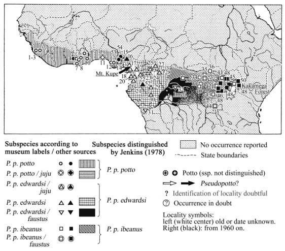
Type localities underlined |
| Home |
|
|
|
Distribution of pottos (genus Perodicticus)
Perodicticus potto potto
Perodicticus potto edwardsi
Perodicticus potto ibeanus
Pseudopotto martini
|
Type localities underlined |
Based on Bartholomew 1979;
Diercke
Weltatlas 1957, Christopher 1984
and Gwangogwe
et al. 1985 (geographic and historical
information);
distribution maps by Fiedler 1956; Jenkins 1987; Kingdon 1971;
Osman Hill 1953; Rowe 1996;
Sanderson
1940 and data from authors mentioned in
the list
below.
Potto forms: list of origin of described animals / specimens
General distribution
Tropical forest belt of west,
central
and east Africa; the northern border of rainforest is apparently
the northern
limit of distribution. From Sierra Leone across the forest zone
to the
Mau Forest, western Kenya. In east Africa in almost all moist
forest areas
of Uganda and west Kenya and in the lower montane forests of
Elgon and
Ruwenzori (Kingdon, 1971; Jenkins, 1987). According to Sanderson
(1940),
in the assumed distribution area of P. p. potto there is
a gap in
the forest cover extending to the shore which causes an almost
complete
rainforest faunal break (see also enclosed map of rain forest
cover and
faunal barriers). Between this break and the distribution area
of P.
p. edwardsi forms in some regard intermediate between P.
p. potto
and P. p. edwardsi have been found (Osman Hill 1953;
Jenkins 1987).
P.
p. juju has been regarded as distinct or as such an
intermediate form
(Jenkins 1987).
| No. | Origin | Altitude | Date | (Source) |
| 7 | Axim,
Ashanti, Gold
Coast,
040 52I N 020 14I W |
Prior to 1871 | (Jenkins, 1987) | |
| 8 | Dunkwa,
Gold Coast,
050 59I N 010 47I W |
Prior to 1913 | (Jenkins, 1987) | |
| 9a | Ejura,
Ashanti, Gold
Coast,
070 23I N 010 22I W |
1935 | (Jenkins, 1987) | |
| 9b | Mampong,
Ashanti, Gold
Coast,
(? 070 04I N 010 24I W) |
360 m | 1935, several specimens | (Jenkins, 1987) |
| 10 | Oda,
Gold Coast,
(? 050 55I N 000 59I W) |
120 m | 1946, several specimens | (Jenkins, 1987) |
| Not found on maps: | ||||
| Trans-Bia, Gold Coast | 30 m | 1970, several specimens | (Jenkins, 1987) | |
| Gold Coast, no exact locality noted, captive, Zoological Society London | 1970, several specimens | (Jenkins, 1987) | ||
| Nigeria: | ||||
| 11a | Lagos,
060
27I
N 030
23I
E
Listed as P. p. juju |
1926 | (Jenkins, 1987) | |
| 11b | Iju
Waterworks, near
Lagos,
060 N 030 E |
Prior to 1920 | (Jenkins, 1987) | |
| 12 | Warri Province, 050 N 050 E | 1944 | (Jenkins, 1987) | |
| 13 | Nikrowa
Forest Reserve,
N. Benin,
060 14I N 050 21I E |
1948 | (Jenkins, 1987) | |
| Not found on maps: | ||||
| Ilotsi, Iloro Forest Reserve | 120 m | Prior to 1946 | (Jenkins, 1987) | |
| Southern
Nigeria
Holotype of P. p. juju |
Prior to 1902 | (Jenkins, 1987) | ||
| No. | Origin | Altitude | Date | (Source) |
| 17 | Bambulua, Manenguba Mts. Distr., S. Cameroons | (Schwarz, 1931) | ||
| 18a | Ober
Canga Ham, Babua
Yabassi,
040 28I N 090 58I E |
1914 | (Jenkins, 1987) | |
| 18b | Edea, 030 48I N 100 08I E | 1932 | (Jenkins, 1987) | |
| 18c | Victoria, Distr. S. Cameroons | (Schwarz, 1931) | ||
| 18d? | Mundame, upper Mungo River, S. Cameroons | (Schwarz, 1931) | ||
| 19 | Yaunde | (Schwarz, 1931) | ||
| 20a | Bipindi, east of Longji, Distr. Kribi | (Schwarz, 1931) | ||
| 20b | Ajos Hill near Kribe (= Kribi?) | (Schwarz, 1931) | ||
| 21 | Alen, near N.E. Border of Rio Muni | (Schwarz, 1931) | ||
| 22a | Sangmelima, Distr. Ebolowa | (Schwarz, 1931) | ||
| 22b | Mouth of Lobo River, upper Dscha River, Distr. Ebolowa | (Schwarz, 1931) | ||
| 22c | Bitye,
River Ja (Dja),
030 01I N 120 22I E |
610 m | 1906, 1909, 1914 | (Jenkins, 1987) |
| 22d? | 030 N 130 E | 1935 | (Jenkins, 1987) | |
| 23a | Lomie
District (N´Jem
Tribe),
030 15I N 130 30I E |
1936 | (Jenkins, 1987) | |
| 23b | Near Beba (= Biba Is.), Lomie District, 030 01I N 130 41I E | 1932 | (Jenkins, 1987) | |
| 24 | Between Batouri and Lomie, Batouri District, 030 45I N 130 45I E | 1935 | (Jenkins, 1987) | |
| 25a | Lelo,
Batouri District,
040 20I N 140 07I E |
1932 | (Jenkins, 1987) | |
| 25b | Beri,
Batouri District
(Kaka tribe),
040 25I N 140 20I E |
1932 | (Jenkins, 1987) | |
| 25c | S.W. of Batouri (Gadgi Kaka Tribe) | 1070 m | 1935 | (Jenkins, 1987) |
| 25d | Lumbindou
Village,
Yambasa, (Kaka Tribe), Batouri
(? = Yamsamba village, Lumbindon = the chief?) |
1932 | (Jenkins, 1987) | |
| Not found on the map: | ||||
| Bamatchem, Distr., Bamun, French Cameroons | (Schwarz, 1931) | |||
| Equatorial Guinea / Rio Muni: | ||||
| 26a | Benito River, 15 miles from mouth, Rio Muni, 010 36I N 090 37I E: | ca. sea level | 1898 | (Jenkins, 1987) |
| Holotype, paratype of Perodicticus batesi Winton 1902, third specimen | ||||
| 26b | Rio Muni (no locality) | (Schwarz, 1931) | ||
| Central African Republic: | ||||
| 27 | Buar (Bouar), east of Nana, upper Sanga (Sangha) River, Distr. Uam Pende | (Schwarz, 1931) | ||
| 28 | Carnot, upper Sanga (Sangha) River, Distr. Manbere-Lobaye | (Schwarz, 1931) | ||
| Congo, former Middle Congo: | ||||
| 29 | Etumbi
(Etoumbi),
000 01I N 140 57I E |
1927 | (Jenkins, 1987) | |
| 30 | Mfôa
(Mfoua),
Como River, 80 miles east of Gaboon,
020 19I S 140 36I E |
1896 | (Jenkins, 1987) | |
| No. | Origin | Altitude | Date | (Source) |
| Zaïre, former Belgian Congo: | ||||
| 31 | Kiniati,
Majumbe (Mayumbe),
050
20I
S 120
56I
E,
listed as P. p. faustus |
Prior to 1912 | (Jenkins, 1987) | |
| 32 | Irneti,
Bompona, River
Maringa, 000
N 19-210
E,
holotype of P. p. faustus |
370 m
|
1910 | (Jenkins, 1987) |
No information about subspecies, but within P. p. edwardsi distribution area:
| No. | Origin | Altitude | Date | (Source) |
| Nigeria: | ||||
| 53 | Mamu, south-eastern Nigeria (one animals shot) | 1963-1967 | (Jewell, Oates 1969 a) | |
| 54 | Nsukka, south-eastern Nigeria. Several animals collected | 1963-1967 | (Jewell, Oates 1969 a) | |
| No. | Origin | Altitude | Date | (Source) |
| Ituri River, Distr. Ituri, Belgian Congo | (Schwarz, 1931) | |||
| Penge, Ituri River, Distr. Ituri, Belgian Congo | (Schwarz, 1931) | |||
| Meje, Nawa River, Distr. Ituri, Belgian Congo | (Schwarz, 1931) | |||
| Kunungu,
near Bolobo,
Distr. Bas Congo,
listed as P. p. faustus |
(Schwarz, 1931) | |||
| Uganda: | ||||
| In almost all moist forest areas of Uganda | Prior to 1971 | (Kingdon, 1971) | ||
| 45 | Bundonga Forest, Masindi, (Bunjoro), 010 45I N 310 36I E | ? | (Jenkins, 1987) | |
| 46a | Ntotoro,
Bwamba,
000 49I N 300 07I E |
760 m | 1949 | (Jenkins, 1987) |
| 46b | In the lower montane forest of the Ruwenzori | Prior to 1971 | (Kingdon, 1971) | |
| 47 | Mabira
Forest, Kyagwe,
000 30I N 32055I E |
1180 m | 1935 | (Jenkins, 1987) |
| 48 | Localities on published map without locality names | (Kingdon 1971) | ||
| Not found on map: | ||||
| Mpanga
Forest, Buganda,
? 000 40I N 300 17I E or 000 06I N 320 23I E |
1957/58 | (Jenkins, 1987) | ||
| Kenya: | ||||
| In almost all moist forests of West Kenya | Prior to 1971 | (Kingdon, 1971) | ||
| 49 | Kakamega
Forest, British
East Africa / Kenya, 000
16I
N 340
53I
E,
type locality of P. p. ibeanus |
1917 | (Jenkins, 1987) | |
| 49b? | (= "Kakumega Forest, Uganda"?) | Schwarz, 1931) | ||
| 50 | In the lower montane forest of Mt. Elgon | Prior to 1971 | (Kingdon, 1971) | |
| 48 | Localities on published map without locality names | (Kingdon, 1971) | ||
| Not found on map: | ||||
| Mau Forest, West Kenya | Prior to 1971 | (Kingdon, 1971) | ||
Pseudopotto
(genus
proposed, might be a synonym for P. p. potto):
list of origin of described specimens
| No. | Origin | Altitude | Date | (Source) |
| Type locality: unknown. Type specimens from Zürich Zoo, duration of captivity not recorded (Sarmiento 1997/98). Trade origin: "Equatorial Africa", "The Cameroons" (Schwartz 1996) | ||||
| 51 | Reported from Mt. Kupe, Cameroon | 2000 | (WWF-CPO website, 2000) | |
| (no information how animals were distinguished from Perodicticus) | ||||
| http://www.species.net/primates/loris/index.html
Lorises and pottos: species, subspecies, local populations |
Last
amendment: 14
April 2002
|